Recent research & fieldwork : Prehistoric Group

The articles below record research and fieldwork undertaken by the Society. Many have not been published elsewhere. Click on the item header or the 'Read more' link to read the complete article.

Chaldon Report 2012 and 2020

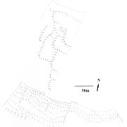
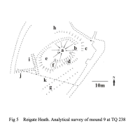
Transcription of aerial photographs by Simon Crutchley (English Heritage) led Mike Russell (2002) to suggest the presence of a prehistoric field system at land on Willey Farm, Chaldon, and that it might be associated with the nearby hillfort known as either War Coppice or Cardinal’s Cap. A visit to the area showed that some of the field boundaries appeared as above ground earthworks and it was decided that an analytical survey would be undertaken by members of the Prehistoric Group. An interim report was published in 2012 below. A report on the completed work has been published in 2020 and is available as a pdf attachment to this page.

Charlwood Excavation 2019

In November 2019 the final season at this muddy site took place. The intention was only to complete excavating a few features which had been left unfinished in 2018 when the team had to leave the site due to the deeply unpleasant conditions caused by the ‘Beast from the East’. Fortunately November 2019 was rather kinder and in spite of some rainy days there were enough dry ones for the work to take place within few days. In November 2019 the final season at this muddy site took place.

Charlwood Excavation 2018


In March 2018, a trench was opened to investigate a pit and ditch formation found in 2017 to the east of the known site. However, due to the weather and soil conditions it was not possible to undertake much work safely for either the archaeology or the volunteers (who were remarkably determined in spite of the challenging conditions). We now hope to return to deal with unfinished business in the autumn.

An analytic survey of Dry Hill Camp 2011-2013

Dry Hill Camp is a large enclosure of probable Iron Age date looking across the Eden/Medway Valley to the northern part of the Low Weald and North Downs. It is multi-vallate and lies just within Surrey, close to both Kent and Mid-Sussex. An excavation in 1932 recovered few finds and the site remained enigmatic. From 2011-2013 a level 3 tape and compass survey to check the condition of the earthworks was undertaken and a report is now available in the pdf attached below.

Reigate Heath Survey 2009-10

During the winter of 2009-2010 a topographical survey of the barrow cemetery on Reigate Heath commenced. This area is centred at TQ 237504, and there are eight scheduled mounds. None of these mounds can be certainly identified as Bronze Age barrows although in the early 19th century a number of mounds were used to plant conifer clumps and finds in two of these suggested that they were burial mounds (Glover 1814). It is also possible that natural dunes and ridges of harder rock were used and the monuments cannot now be identified by above ground evidence alone.

Pages