
Reigate Heath Survey - Judie English & Rose Hooker
During the winter of 2009-2010 a topographical survey of the barrow cemetery on Reigate Heath commenced. This area is centred at TQ 237504, and there are eight scheduled mounds. None of these mounds can be certainly identified as Bronze Age barrows although in the early 19th century a number of mounds were used to plant conifer clumps and finds in two of these suggested that they were burial mounds (Glover 1814). It is also possible that natural dunes and ridges of harder rock were used and the monuments cannot now be identified by above ground evidence alone.
All scheduled barrows and possible barrows are being surveyed in detail at a scale of 1/200. The results so far are available as an interim report by contacting the authors. There are two more mounds which remain to be examined and possibly surveyed, after which a survey of the heathland surrounding all mounds will take place in order to set them within their landscape context. Barrow studies now recognise the importance of the relationship of mounds with both natural and manmade landscapes.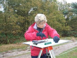
Reigate Heath lies on the Folkestone Beds of the Lower Greensand which supported only open heathland and decorative conifer clumps until the early 20th century, after which scrub woodland has encroached. The soil state and vegetation before barrow construction is unknown and such information would be useful for understanding both the previous land use and for sight lines related to the monuments once built.
Most of the mounds on Reigate Heath form a linear cemetery which runs along the south-west facing edge of a ridge which forms the watershed between two streams, both of which feed into the river Mole. Linearity here is a reflection of the topography, but an association between linearity and lineage in such barrow groups has been considered (Garwood, 2007, 43). In general, these cemeteries are seen as late in the Bronze Age period, with most dated to c1850-1500BC (ibid, 2007).
The topographic position of prehistoric barrows in the South East has recently been assessed (Field, 1998). In the western end of the Weald many cemeteries occur on the greensand but in Surrey and
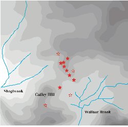 Some round barrows cluster close to water, especially lakes and meres (Tomalin 1996, 15-19), or can be set around valley heads overlooking springs (McOmish et al 2002). Modern drainage and water extraction makes it difficult to reconstruct the prehistoric environment, but peat deposits around the headwaters of the Wallace Brook suggests that the linear cemetery may have overlooked marshland, and several ponds survived on Reigate Heath into the early twentieth century.
The structure of the barrows and any evidence of rituals pre-dating or accompanying their construction, and the presence or absence of secondary burials in the mounds or flat graves around them are all unknown, but, the open spaces around the barrows on their ridge, with water or marshland to the south and a backdrop of the North Downs towering behind them, could have provided a suitable setting for such rituals.
Any greater understanding of this cemetery would be assisted both by positive identification as prehistoric of each mound, and by some knowledge of the environment during their construction. There is also an issue of protection: all are to varying extents being damaged, however inadvertently, by heavy leisure use.
This fieldwork is taking place in accordance with a Research Design approved by Ann Clark (English Heritage) and has been facilitated by the Ranger, Ian Wright (
References:
Field, D 1998 Round barrows and the harmonious landscape: placing Early Bronze Age burial monuments in south-east
Garwood, P 2007 Before the hills in order stood: chronology, time and history in the interpretation of Early Bronze Age round barrows, in Last, J (ed) Beyond the grave: new perspectives on barrows, Oxbow Books 30-52
Glover, A 1814 An account of the opening of some barrows on Reigate Heath Archaeologia 17, 325-326
McOmish, D, Field, D & Brown, G 2002 The field archaeology of the Salisbury Plain Training Area, English Heritage
Tomalin, D 1996 Towards a new strategy for curating the Bronze Age landscape of the Hampshire and Solent region, in Hinton, DA & Hughes, M (eds) Archaeology in Hampshire: a framework for the future, Hampshire County Council